
Collecting data offline using Acorn DCT
The following topics will be discussed in this article:
An introduction to offline collection
Video: how to download offline maps
Downloading an offline map
How to download and update offline maps
What to take into account while collecting offline
Submitting farmers' profiles
An introduction to offline collection
To collect a farm's data with DCT, data collectors will need to visit the farm and farmer. Often, these farms are in remote locations without a strong internet connection.
Since good internet connection is not guaranteed during the data collection process, the Acorn DCT app allows data collectors to collect data offline.
After collecting a farm's data offline, a Data Collector can return to a place with good internet connection to submit the data to the Local Partner portal.
With the right preparations, collecting data offline can be done just as smoothly as online. However, collecting data without these preparations might cause issues like plot overlap, requiring a data collector to revisit the same farm.
This article will provide you with the necessary information to collect data offline using DCT in the correct and efficient way.
Downloading an offline map
Offline maps to deal with GPS inaccuracies
When tracking a plot in DCT without an internet connection, you might notice that the tracking screen displays a gray grid instead of satellite images. This is because the satellite images are not downloaded on your phone when installing the Acorn DCT app. This minimizes the amount of storage space the DCT app takes up on a data collector's phone.
While tracking a plot, it is essential to look at the satellite images to make sure your phone's GPS is working properly, and you are tracking the correct plot of land. GPS inaccuracies can cause a marker to be placed thousands of meters away from where you are standing.
By looking at the satellite images, you can spot any GPS inaccuracies before tracking the whole plot. You can then calibrate your phone's compass before tracking the plot again.
Offline maps to prevent overlap
Offline maps in DCT do not only consist of satellite images, but also include polygons that were tracked in a certain area. Downloading an offline map therefore helps data collectors prevent overlap with existing plots.
Since new plots can be tracked every day by other data collectors, it is important that your offline map is up-to-date. An offline map that was downloaded last week will not include any polygons that were collected yesterday. It is therefore important to delete and re-download your offline map whenever you have internet, preferably right before you leave for data collection.
DCT will not automatically update these maps, even if you are connected to the internet. Always make sure your map is updated before you visit a farmer.
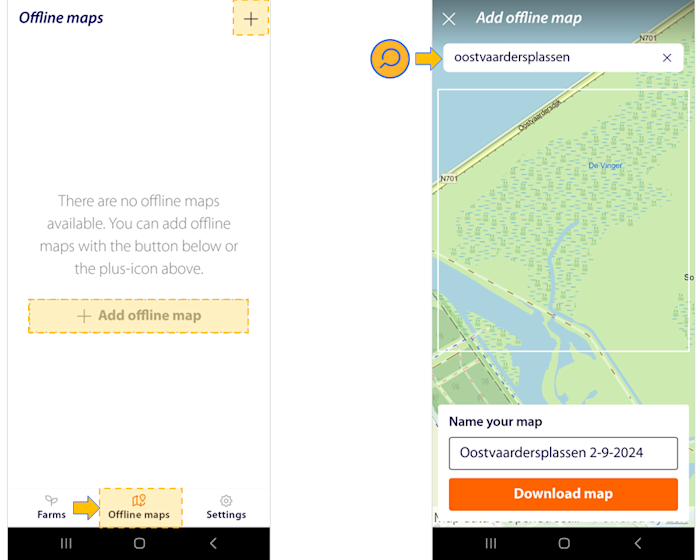
How to download offline maps
Open the DCT Android app
Navigate to the 'offline maps' section of the app
Tap the 'Add offline map' or the '+' button
Search for the area you will visit
Name your map
Tap the orange 'Download map' button
How to update an offline map
Navigate to the 'offline maps' section of the app
Tap on the name of the map you want to update
Tap the red bin button in the top right and tap 'Delete'
Re-download the map of the area
What to take into account while collecting offline
As mentioned in the previous section, offline maps can prevent overlap and similar issues while collecting data offline.
For this reason, it is important to keep an updated version of the map on your phone. Ideally, updating your offline map is the last thing you do before you leave to collect data.
Even when you follow these steps, it might happen that two data collectors are collecting farm data in the same area at the same time. Offline maps will not show unsubmitted plots from other data collectors, so this might cause issues after submission. A local partner should keep this in mind while organizing data collection efforts.
Submitting farmers' profiles
Data can be collected offline using Acorn DCT app. After farm data is collected, it needs to be submitted to the Local Partner Portal.
To submit data, a stable internet connection is needed. Please refer to this article for more information on how to submit data.