
In the world of agroforestry and carbon markets, biomass satellite measurements are an essential piece of the puzzle. These measurements generate the data used in models that make up the foundation of Acorn’s carbon credit system. Here are four upcoming cutting-edge satellite developments that can enhance Acorn’s agroforestry and biodiversity measurements.

Computer-generated image of the ESA’s biomass satellite over a forest. Source: The European Space Agency
1. ESA’s Biomass Satellite
Sensor Wavelength: ~70 centimeters
Resolution: 200 meters
Acorn currently uses Sentinel-1 and Sentinel-2 as our primary satellites for remote biomass sensing. Sentinel-2 carries an optical payload with visible, near infrared and shortwave infrared sensors comprising 13 optical spectral bands between 400-2500 nanometers, while Sentinel-1 is a C-band synthetic-aperture radar sensor. As these sensors use short wavelengths, they have certain limitations when it comes to measuring beneath the forest canopy, where most of a forest’s true biomass lies.
The European Space Agency (ESA), however, is introducing a game-changer for remote biomass sensing: a low orbit satellite platform carrying a P-band synthetic aperture radar instrument. This sensor’s wavelength is longer (~70cm), which makes it a superior sensor for biomass measurements.
“The difference is quite significant,” explained Xi Zhu, Acorn’s remote sensing data scientist. “Shorter wavelength sensors can reach the branches and the leaves on the top of the forest canopy. So you are basically using the proxy of the canopy to measure the biomass. The advantage of the longer P-band radar sensor is that it can reach through the canopy to the stem of each individual tree, giving us a much better biomass estimation from this sensor.”
The ESA satellite’s sensor is also better able to bypass the cloud cover that currently limits Sentinel-2. The new satellite, scheduled for launch in 2024, is expected to cover the entire globe with a resolution of around 200 meters.
2. NISAR by NASA
Sensor Wavelength: ~24 centimeters (L) and 10 centimeters (S)
Resolution: 5-10 meters
Measurement Interval: 4-6 times a month
Another exciting development comes from NASA: the NASA-ISRO Synthetic Aperture Radar, or NISAR, also scheduled for launch in 2024. NISAR carries an L-band and an S-band radar sensor, which is also a longer wavelength. It’s designed to observe and measure some of the planet's most complex natural processes. For this purpose, its sensor provides a resolution of 5 to 10 meters, providing valuable higher-resolution measurements for agroforestry and biodiversity metrics.
The combination of advantages offered by longer wavelength sensors like ESA’s Biomass satellite and higher-resolution measurements from NISAR will allow Acorn to explore potential synergies between different satellites for optimal data-gathering.
“We will have to test how to combine the sensors and test for the accuracy of each one, but we could be entering into an era of multiple-sensor fusion for our biomass measurements”, said Zhu.
3. Hyperspectral Sensors
Sensor Wavelength: 400+ bands, 400-2500 nanometers
Resolution: 10 meters (Pixxel), 30 meters (Tanager)
Measurement Interval: Every 5-10 days
Despite these other advances, optical sensors like those currently used on Sentinel-2, still have a place in biomass estimation. Planet, a private satellite innovation lab, is expected to launch their new take on optical sensors in 2024, with the ‘hyperspectral’ Tanager I and II.
Zhu explained a hyperspectral sensor’s capabilities: “Unlike a radar sensor, Tanager does not penetrate cloud cover and does not penetrate the canopy. However, its hyperspectral optical sensor utilizes more than 400 bands, ranging from 400 to 2500 nanometers.” For comparison, the Sentinel-2 satellite is a multispectral sensor with 13 bands.
Pixxel, another private satellite company, is working on its own hyperspectral offering that is very similar to the sensor offered by Tanager. Both satellites will aim to take measurements at a high frequency rate, every 5-10 days.
“With the many narrow bands and frequent measurements offered by the hyperspectral sensors of Tanager or Pixxel,” Zhu continued, “we can gather incredibly detailed data from the leaves of plants, such as water, chlorophyll, and nitrogen content.”
This level of detail allows for the identification and mapping of specific kinds of trees and crops. This will not only improve the accuracy of biodiversity measurements and Acorn’s modeling capabilities, but will also benefit farmers by helping them better understand which tree species are most beneficial for their ecosystems.
Hyperspectral image (right) revealing detail that is unobservable in the optical image (left). Source: Pixxel
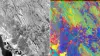
Hyperspectral image (right) revealing detail that is unobservable in the optical image (left). Source: Pixxel
4. Thermal Sensors
Sensor Wavelength: 8-14 micrometers
Resolution: 10-30 meters
Measurement Interval: Every 5-10 days
The Future of Satellites and Acorn’s Mission
Another new sensor innovation, from private company Constellr, offers something entirely different: thermal data, which measures land surface temperature.
Zhu detailed how these sensors can offer insights into tree survival rates, drought indices, and even help predict fire risks. The thermal sensor's higher resolution positions it as a crucial tool for assessing agroforestry suitability and mitigating potential risks.
The ESA biomass satellite, NISAR, Tanager, Pixxel and thermal sensors collectively represent a new frontier in precision and efficiency. Acorn's commitment to integrating these advancements into our own technologies and modeling capabilities underscores our dedication to sustainability and innovation in the carbon market. The future promises a more nuanced understanding of agroforestry ecosystems, allowing us to continue to ensure that our carbon credits are always accurate, transparent, and validated.

An example of thermal sensor satellite imaging of a monster cyclone. Source: NOAA/NASA
About Acorn
We help support smallholder farmers in developing countries transition to agroforestry. Together with local partners, we facilitate the funding and training needed by farmers to start their agroforestry transition. Transforming the sequestered CO2 through agroforestry into Carbon Removal Units (CRUs), we offer carbon credits to responsible corporates to help them reach their climate goals. The growth of the trees is measured with satellite imagery, AI and LiDAR, and certified by ICROA-accredited Plan Vivo.
With 80% of the sales revenue going directly to the farmers, it creates an additional income stream and helps them adopt a more climate-resilient way of farming that improves food security, biodiversity, and financial independence.
Get involved with Acorn